[vc_row][vc_column][vc_column_text]
Information which was provided on this page is the current condition or information pertaining to the occurrences of the forest and land fire, hotspot distribution, the estimated extent of forest and land fire, and information for the of ease the potential occurrence of forest and land fire in terms of the weather analysis in Southeast Asia.
Early warning and monitoring of land-use fires, wildfires, and smoke-haze are conducted by several institutions inside and outside the ASEAN region. The institutions listed in the following provide near-real-time or periodic early warning and fire monitoring information. These websites allow access to more detailed national/sub-regional wildland fire information:
Early Warning of Wildland Fire Danger
Fire Danger Rating System (FDRS) The Regional South East Asia Fire Danger Rating System (SEA FDRS) began as a joint effort between the Canadian Forest Service and the Canadian International Development Agency (CIDA), in cooperation with the Malaysian Meteorological Service (MMS). Now, the FDRS is managed by the Malaysian Meteorological Department (MetMalaysia) and updated on a near-daily basis; maps such as the Fine Fuel Moisture Code are available.
Link: http://www.met.gov.my/web/metmalaysia/climate/fdrs/southeastasia
Fire Danger Rating for East Kalimantan, Indonesia
The Integrated Forest Fire Management (IFFM) project in Indonesia is supported by the German Agency for Technical Cooperation (gtz) and the Global Fire Monitoring Center (GFMC). IFFM has been working with a Fire Danger Rating (FDR) system in East Kalimantan since 1995. The FDR is based on the Keetch-Byram Drought Index (KBDI) and is part of the Fire Information System (FIS) which manages spatial fire-related data and information in an integrated manner.
http://www.pkhl.or.id/grafikfdr.htm (link not available)
Fire Danger Rating for South Sumatra, Indonesia
The Forest Fire Prevention and Control Project (FFPCP) is a joint enterprise between the European Commission and the Indonesian Ministry of Forestry and Estate Crops. FFPCP is based in Palembang, South Sumatera, and is obtaining a clear understanding of the causes and effects of forest fires. This information is used to develop and implement practical methods of prevention and control. Government, community and commercial interests are integrated to reduce fire risk, damage and use.
The Fire Index for South Sumatra is based on the Keetch-Byram Drought Index (KBDI) that has been adapted for Indonesia (see Fire Danger Rating in East Kalimantan).
Access: http://www.mdp.co.id/ffpcp/Index.htm (link not available)
The South Sumatra Forest Fire Management Project based in Palembang (South Sumatra) provides daily forest fire occurrence and weather information: http://www.ssffmp.or.id/ssffmp/fwi.asp (link not available) and with additional fire location map (derived from MODIS Rapid Response System) http://www.ssffmp.or.id/ssffmp/fwi-2.asp?id=2 (link not available)
Indonesia National Weather Information of the BMKG (Meteorological, Climatological and Geophysical Agency)
Forest Fire Warning System
Link: http://www.bmkg.go.id/cuaca/kebakaran-hutan.bmkg?lang=EN
Malaysian Meteorological Service
Link: http://www.met.gov.my[/vc_column_text][/vc_column][/vc_row][vc_row][vc_column][vc_tta_accordion style=”modern” color=”green” c_icon=”chevron” active_section=”0″ collapsible_all=”true”][vc_tta_section title=”Current Regional Fire Status” tab_id=”1511229379471-92727cee-6a28″][vc_column_text]
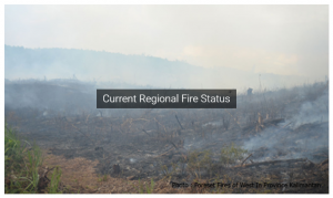 |
Information that gives descriptions of the forest and land fire occurring current. Hotspot and climate are an indicator of to perform early detection to forest and land fire don’t occur widespread. Information hotspot and climate were devoted in Southeast Asia. See more…
[/vc_column_text][/vc_tta_section][vc_tta_section title=”Current Global Fire Status” tab_id=”1511229785219-604e2f82-b28e”][vc_column_text]
 |
Note: The statements or opinions made by writers under media articles is the notion derived from personal writers with data-data or information he did to strengthen the view. RFMRC – SEA doesn’t have authority change the article for having copyright based on applicable plagiarism law. Statements or opinion it could be right or variance with a view RFMRC – SEA based on research done. See more…
[/vc_column_text][/vc_tta_section][vc_tta_section title=”Regional Fire Weather and Smoke Pollution Early Warning” tab_id=”1511229496028-027c7ebc-f6aa”][vc_column_text]
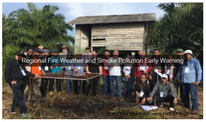 |
Early warning (fire intelligence) systems are essential components of fire and smoke management. They rely on the evaluation of vegetation dryness and weather; detection and monitoring of active fires; integrating and processing of these data in fire information systems with other relevant information, e.g. vegetation cover and values at risk; modeling capabilities of fire occurrence and behavior; and dissemination of information.
Early warning of fire and atmospheric pollution hazard may involve locally generated indicators, such as local fire-weather forecasts and assessment of vegetation dryness. Advanced technologies, however, which rely on remotely sensed data, evaluation of synoptic weather information and international communication systems (e.g., Internet) are now also available for remote locations.
In this report, the large variety of standards, methods, and technologies of fire and smoke management which are used in national programs cannot be described in detail. Generally speaking, however, it is obvious that, due to the lack of resources, fire management systems are disproportionately less available in developing countries.
Fire weather is the use of meteorological parameters such as relative humidity, wind speed and direction, cloud cover, mixing heights, and soil moisture to determine whether conditions are favorable for fire growth and smoke dispersion. The fire weather products we issue such as the Fire Weather Planning Forecast, Fire Weather Watches, Fire Weather Warnings, and Spot Forecasts are generally intended for land management agencies.
Source:http://gfmc.online/other_rep/programmes-other_rep/un-programmes-other_rep/idndr_in-2.html#Recent
[/vc_column_text][/vc_tta_section][vc_tta_section title=”Other Satellite and Ground Monitoring Products” tab_id=”1511229700100-796091df-9e38″][vc_column_text]
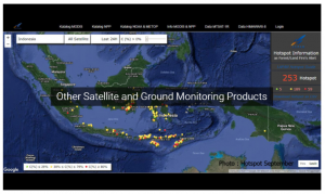 |
RFMRC – SEA using data NASA FIRMS (Fire Information for Resource Management System) and LAPAN (Lembaga Penerbangan dan Antariksa Nasional) derived from MODIS Satellite projected to Google Earth to see the hotspot in the Southeast Asia Region so that it can be analyzed by the Governmental and Non Governmental or organizations forestry or organizations that focus on handling forest and land fire.
[/vc_column_text][/vc_tta_section][vc_tta_section title=”Current News Regional and Global” tab_id=”1511229637037-7ea217e5-ff07″][vc_column_text]
 |
[/vc_column_text][/vc_tta_section][/vc_tta_accordion][/vc_column][/vc_row]