Yet again, the Kingdom this year burns brighter than its neighbors, with fires in Cambodia being detected from space at a much higher rate than any other country in the region, according to a NASA report published last week.
It’s likely a product of both naturally occurring blazes and also those caused by land clearing, especially on concessions.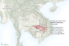
Fig.1 A map showing forest fire detections on February 3, 2018, by the Visible Infrared Imaging Radiometer Suite (VIIRS) on the Suomi NPP satellite. Courtesy of NASA/The Earth Observatory
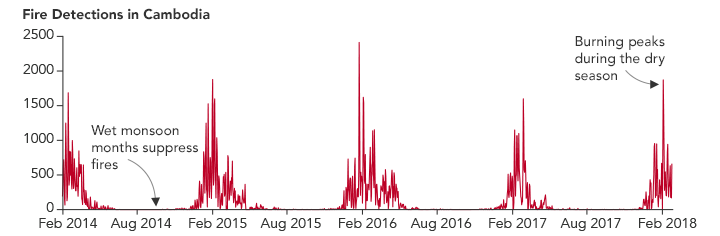
Fire season, which runs from January through March, but can extend as late as May, reached its 2018 peak on February 3, when NASA’s Earth Observatory picked up some 1,868 active fires in Cambodia. That compared to 217 in Thailand, 185 in Laos, 114 in Vietnam and 77 in Myanmar.
“The pattern is consistent with recent years,” according to a brief report from the public outreach arm of the US National Aeronautics and Space Administration. “[T]he instrument has detected four-to-five times as many fires in northern Cambodia as it did in Vietnam and Thailand between August 2016 and February 2018.”
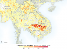
Fig.2 A map showing the cumulative detection of fires since 2006 by the Visible Infrared Imaging Radiometer Suite (VIIRS) on the Suomi NPP satellite. Courtesy of NASA/The Earth Observatory
Chea Sam Ang, head of the Environment Ministry’s General Directorate for Administration of Nature Conservation and Protection, said annual fires in deciduous forests are a natural occurrence, burning surface debris, and grasslands, but leaving large trees unharmed. Simon Mahood, Wildlife Conservation Society–Cambodia senior technical adviser, agreed a portion of the burning is a natural part of the ecology.
“Cambodia has more [deciduous] forest than its neighbors. For a start, that’s definitely a factor,” he said. “The vast majority of fires are set by people.”
While many fires are from slash-and-burn agriculture, hunting, foraging and resin collection, as well as land grabbing, land clearing on concessions is the key factor, Sam Ang said.
“From the land concessions, when they clear the land they clear the forest for agriculture so after they collect the timber, they set the fire,” he said. “We have more [fires] because of land clearing for the [economic] land concessions and social land concessions.”
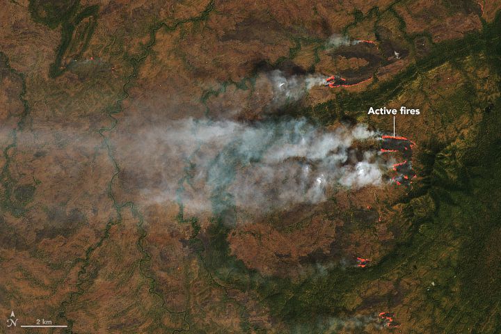
Fig.3 A natural-color image captured on February 1 by the Landsat 8 satellite shows fires burning in shrub-lands near a forested ridge in the Srepok Wildlife Sanctuary. The area burning is overlain in orange. Courtesy of NASA/The Earth Observatory
There is also a correlation between logging and forest fires, according to NASA’s report.
“Loggers use fire to clear roads and to clear the land after harvesting the most desirable species,” they wrote, noting that without information on the ground it is impossible to determine what caused a given fire from the satellite imagery.
This wouldn’t be the case in evergreen forests – such as in Virachey National Park – where hardly any fires are observed, Sam Ang and Mahood said.
Sam Ang added that fires are “not a priority” issue, though the ministry monitors and works with local villagers on fire education.

Graph of fire detections in Cambodia by Visible Infrared Imaging Radiometer Suite (VIIRS) on the Suomi NPP satellite over time. Courtesy of NASA, The Earth Observatory