Skip to content
  • Thursday, January 15, 2026
RFMRC-SEA

RFMRC-SEA

Regional Fire Management Resource Center – South East Asia

  • Home
  • ABOUT RFMRC – SEA
    • Introduction to RFMRC-SEA
    • RFMRC – SEA ACTIVITIES
    • Partners
    • Contact
  • CURRENT FIRE AND FIRE WEATHER INFORMATION
    • Current Regional Fire Status
    • Current Global Fire Status
    • Regional Fire Weather and Smoke Pollution Early Warning
    • Other Satellite and Ground Monitoring Products
    • Current News Regional and Global
  • FIRE SCIENCE PORTAL
    • Regional
    • International
  • RESOURCES
    • Resources for Policy Makers
    • Resources for Practitioners
    • Resources for Public
    • International Wildfire Preparedness Mechanism (IWPM)
    • International Fire Aviation Guidelines
    • Research and Employment Opportunities
  • GLOBAL WILDLAND FIRE NETWORK
    • GWFN Secretariat: Global Fire Monitoring Center (GFMC)
    • Sister-Centers
    • Regional Wildland Fire Networks
    • International Peatland Fire Network
  • RFMRC – SEA ACTIVITIES
    • Webinar on Fire Prevention for Sustainable Peatland Management: Policy and Practices
  • ARCHIVE
    • RESEARCH AND PUBLICATIONS
      • Research
      • Publications
  • REGIONAL ACTORS
  • VIDEO GALLERY
  • BURN FREE MOVEMENT INDONESIA
  • PM 2.5
  • Home
  • Environment
  • Page 2

Category: Environment

ASEAN Environment Forest Fire Forestry Global HAZE RFMRC-SEA SOUTHEAST ASIA

2018 in Environmental Review for Southeast Asia

2018 in Environmental Review for Southeast Asia

November 2, 2018, | By Gregory McCann

As 2018 comes to a close it is worth taking a look at the environmental trends throughout the year, with a special emphasis on those within the last six months or so, in order to gain an understanding of what has been happening to this region’s natural heritage and so that we might know what to look for in 2019—and how to address the upcoming challenges.

While we can say that a lot has been happening everywhere, and this is especially true for Malaysia. The country produces durian that Chinese consumers covet. This means rainforests that are currently home to tigers are being converted into plantations so that more and more of the spiky, pungent fruit can be sold to China. That means bad environmental news, with China the driver. Furthermore, clearing forests will drastically reduce the number of pollinators such as bats and other wild animals, which will, in turn, lower the durian’s quality.

Another fruit—palm oil—is almost always the whipping boy for conservation problems in Malaysia (and beyond), however, the country is making headway in its own sustainable certification program, which attempts to incorporate Environmentally Sensitive Areas (ESAs) into development blueprints across Malaysian Borneo. Nonetheless, huge development projects in Peninsular Malaysia are pushing the environment to the breaking point, with gargantuan Chinese-funded residential projects such as Forest City across the strait from Singapore serving as a striking case in point.

However, Prime Minister Mahathir Mohamad recently shut down several Chinese Belt and Road projects.  Malaysia also wants to ban importing plastic waste, as well as single-use plastic straws. Nonetheless, serious problems remain. Even without the durians-to-China issue, tiger numbers are tumbling fast, scenic Langkawi island is coming under so much stress that it may lose its Unesco status, while in Sarawak the forest-dwelling Penan indigenous group continue to block bulldozers and fight for their traditional lands. However, a rehabilitated Bornean orangutan was successfully rewilded in Sabah’s Tabin Wildlife Sanctuary, the first orangutan to fully return to the forest after such a long spell in captivity and rehabilitation, and a clouded leopard was sighted within the vicinity of a local hospital.

Across the Strait, in Indonesia, ecological issues are festering as well. While a new species of songbird has been identified on Rote Island, five other bird species have lost their protected status. The endemic Sumatran laughing thrush is fast disappearing, while the Helmeted Hornbill is relentlessly persecuted in Indonesia. The caged bird trade is bringing many species to the brink of extinction in the archipelago, and biologists say many forests where they work are becoming increasingly “quiet.”

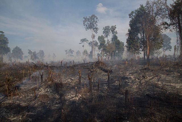
Forest fires raged in South Sumatra and Riau provinces in 2018, and Chinese developers are stubbornly pushing ahead with a hydroelectric dam in the Batang Toru forest, home to the rarest species of the orangutan in the world. The Critically Endangered Sumatra rhinoceros is still in big trouble but there is a movement on to save it, while a pregnant Sumatran tigress was caught and died in a pig trap in Riau.

Like Malaysia, Indonesia has a major palm oil problem, but the country’s anti-graft department says it’s ready to take action against transgressors who are felling natural forest and breaking other laws. Sadly, the Bali government wants to build an elevated highway right on top of some of its last undeveloped sandy beaches. The small volcanic island of Krakatoa in the Sunda Strait between Java and Sumatra has spewed lava and ash this year.   Widespread deforestation, poaching, overfishing, and plastic pollution has been taking over this island nation. Indonesian Presidential contender Prabowo has said that if he is elected to office he will review China’s Belt and Road plans, which could include a cancellation of the Batang Toru dam, and a court in Aceh recently threw down its stiffest penalty to date for two men caught trying to sell a tiger pelt.

Asia Sentinel recently reported on the surprising amount of wildlife to be found in Singapore today. Thailand also received high environmental marks in a recent Asia Sentinel critique, however, Thai-language media recently uncovered a story about a Vietnamese national caught with tiger bones in the kingdom— particularly worrying report as Vietnamese poachers are among the most tenacious in Asia.

Making matters worse, a new and improved road through Kaeng Krachan National Park will likely lead to greater disturbance to the forest’s wildlife, while a few provinces to the north a Burmese national gunned down a binturong. There is rising sentiment to build a Kra Isthmus Canal in Thailand. A large crocodile was caught off the Krabi coast, a whale shark was recently spotted of Koh Racha, and local conservationists have thus far succeeded in fending off a new marina development project in Phuket. However, the deluge of Chinese tourists into the kingdom is pushing Thailand to its breaking point, and it was largely Chinese tourists who are responsible for the closing of Maya Bay in Koh Phi Phi, which remains closed indefinitely so that it can recover.

In Laos, the Nam Theun 2 Dam has been such a disaster that its main financier, the World Bank, has thrown in the towel and walked away.  In Dead in the Water: Global Lessons from the World Bank’s Hydropower Project in Laos contributing author Glenn Hunt remarks: “For one of the pillars that were supposed to be the primary source of income, it’s been an unmitigated disaster.” With about 140 dams either under construction or on the drawing board in its quest to be the “battery of Asia,” Laos faces the potential for most disasters and large-scale environmental and social degradation in a country that has already lost its wild tigers, leopards, and many other species.

Despite the tragedy that unfolded in Attapeu province when a large dam collapsed, Laos remains bullish about constructing more dams. And the dam-building frenzy is harming the environment and wildlife all around the country. And while a recent Guardian write-up describing the fantastic-look am Et-Phou Luey ecotourism program up in the north of the country describes a healthy tiger population in this region, perhaps the author was given old data.

Wild elephants are reportedly being skinned alive in Myanmar to satisfy a new Chinese demand—for “blood beads,” which are blood-filled chunks of elephant fat. The previous link provides a window into some twisted tastes: “The online trader wants his customers to know the elephant was skinned quickly, with blood still fresh in its veins.” Chinese demand for elephant skin used in bags in jewelry was already shocking, but things can always get worse when it comes to wildlife.

But in more uplifting news from the country, Irrawaddy dolphins are being given greater protections, and the government is also cracking down on illegal wildlife trade in the city of Yangon.

Taking note of how poorly elephants working in tourism are treated across Asia, Vietnam has launched the region’s first “ethical elephant experience.” The country has also taken an interest in seeing that its shrimp farming industry become more sustainable, while the government also recently signed a deal with the EU that promises a reduction in illegal logging (though some in neighboring Cambodia have serious doubts about this). We reported earlier this year that Vietnam’s wildlife is in rough shape, and things haven’t taken much of a turn for the better since.

And finally, Cambodia.  A recent camera-trap check-in Virachey National Park so delighted the Ministry of Environment that he shared some of the photos on their Facebook page; even the Thai media took notice of the results. Asia Sentinel reported earlier this year that Cambodia is probably the last hope for Indochina’s wildlife, and this still holds true, despite the fact that nearly 110,000 snares were found in a single national park. A man was recently killed by a wild boar near the Cardamom Mountains, while Kratie province is cracking down on illegal mining, and at the same time, the central government is demanding that villagers who grabbed national park land return it.

In other news from the region, the Maubere tribe of Timor-Leste is bringing back ancient customary laws to help protect its forests, seas, and coastline. Chinese demand for logs is wiping out the forests of the Solomon Islands. India is losing tigers and elephants, while two elephants were struck by a train and killed in Sri Lanka.

As always, China casts a menacing shadow over Southeast Asia and nowhere is this more clear than on the Mekong River and in the South China Sea. The region, with the help of the US and Japan, must find a way to manage Chinese aggression in the South China Sea and beyond, and then some of the numerous dams that it has planned for the region have to be canceled or scaled down.

Beyond that, Chinese citizens have to be educated about wildlife product consumption, including shark fins, tiger parts, bear gallbladder, elephant skin and blood, and much more, which have no known scientific value. And in a shocking and disturbing announcement,  China has said that it will lift its decades-old ban on the trading of tiger parts and rhino horn, a move that will almost certainly put these species in greater danger.  Or else one of the most biologically rich regions of the world loses everything that made it so special.

Gregory McCann is the Project Coordinator of Habitat ID, and the author of Called Away by a Mountain Spirit: Journeys to the Green Corridor. You can support his conservation projects in Cambodia and Sumatra here.

Source Link: https://www.asiasentinel.com/society/2018-environmental-review-southeast-asia/

ASEAN CAMBODIA Environment Forest Fire Forestry Global HAZE RFMRC-SEA SOUTHEAST ASIA

Cambodian PM Vows to Shoot Loggers From Helicopters, Again

Cambodian PM Vows to Shoot Loggers From Helicopters, Again

Published: Tuesday, 02 October 2018 16:33

Cambodian Prime Minister Hun Sen promised on Sunday that he would fix his country’s problems with rampant deforestation by shooting those who illegally chop down timber from helicopters.

mondulkiri deforestation
Deforestation in Mondolkiri, Cambodia (CC 4.0)

“It’s correct that we are losing our forests, many are being replaced by rubber plantations,” he said, speaking to members of the Cambodian diaspora in New York.

“I acknowledge that thieves have illegally cut down timber and I am ordering them to be shot from helicopters in the sky.”

Hun Sen made a similar promise two and a half years earlier when he announced that General Sao Sokha, newly appointed as head of a task force to stop illegal logging and timber smuggling, was authorized to fire rockets at loggers from helicopters.

That order came a year after a Global Witness report showed that Hun Sen’s own personal advisor, Try Pheap, headed an illegal logging network that saw millions of dollars of rosewood smuggled to China each year.

Not a shot has been fired from helicopters since that order and the task force did not succeed in halting the flow of luxury timber across Cambodia’s borders to Vietnam.

Hun Sen’s relatives have also long been linked with the country’s illegal timber business.

With hectares of forest falling to loggers and economic land concessions dished out by Cambodia’s ruling party, the country has one of the world’s highest rates of deforestation.

Global Witness meanwhile estimates that evictions that have resulted from logging and the government giving land to agribusinesses have displaced 830,000 people, forcing some into squatting in state forests or cutting down timber themselves.

Speaking Sunday, however, Hun Sen emphasized that it was the country’s now-defunct opposition–whose leader is in exile and whose deputy leader is just out of prison–that should be blamed for illegal logging.

“In many cases [the thieves] went to cut down millions of hectares to cultivate farmlands, including groups [affiliated] with the former opposition,” he said.

Source Link: https://www.occrp.org/en/daily/8677-cambodian-pm-vows-to-shoot-loggers-from-helicopters-again

ASEAN Environment Forest Fire Forestry Global INDONESIA RFMRC-SEA Wildfire

Forest fire breaks out on slopes of Bali’s Mount Agung

The forest fire breaks out on slopes of Bali’s Mount Agung

Coconuts Bali | 4 days ago

a view of a river: mount agung forest fire bali post sept 28 2018

Mount Agung forest fire Bali post sept 28, 2018

The Suwung landfill in South Denpasar is not the only place burning in Bali at the moment.

A forest fire broke out on the slopes of Bali’s Mount Agung on Thursday.

Wooded areas around Daya and Kubu have been observed smoking, however, this fire’s not an easy one to put out.

The burn area lies inside steep terrain of the eruption hazard zone of Mount Agung, which persists at level III “standby” status for an eruption.

There continues to be an exclusion zone recommended by Indonesia’s volcanology center, encompassing a four-kilometer radius from the volcano crater, which has been extended and reduced back down to four kilometers a number of times since the Bali volcano rumbled back to life last year. Outside of this exclusion zone, Bali remains safe and tourists are urged by the government to still come for holiday.

Head of the Karangasem Fire Department I Nyoman Sutirtayasa said that his department has been coordinating with officers from East Bali Forest Protection Management (RPH) to put out the fire at an altitude of about 1,500 meters above sea level.

“Officers from East Bali RPH are conducting fire monitoring at monitoring posts,” Sutirtayasa told Bali Post on Thursday.

The officers are ready to start fighting the fire if it spreads further down outside of the exclusion zone, but at the moment the terrain is to challenging to access the burn location, according to the fire department head.

“The route to the (fire) location is difficult. The effort that can be done now is to prevent the spread of the fire to the lower slopes. If we go up, we do not dare enter the danger zone,” Sutirtayasa told Tribun Bali.

“The area of land burning is getting wider. The fire has reached the south of Mount Agung and has spread to forested land above Pajenengan Temple, Pempatan Village. The cause of the fire is still unknown,” Sutirtayasa said.

Meanwhile, Made Warta, head of the East Bali Forest Management Unit says that his officers have been working with local residents to try and contain the downward spread of the fire. They also dare not risk entering the danger zone, but they have been extinguishing flames trying to come down the mountain.

There are three apparent hotspots that have appeared and the burn area is estimated to be about a hectare, Warta told Tribun.

There isn’t even a hiking trail to one of the areas, Warta explained of the difficult access.

Hot weather and strong winds have been contributing factors in allowing the fire to spread and flare up.

The post Forest fire breaks out on slopes of Bali’s Mount Agung appeared first on Coconuts.

Source Link: https://www.msn.com/en-sg/news/world/forest-fire-breaks-out-on-slopes-of-bali-e2-80-99s-mount-agung/ar-BBNEAcX

Environment Forest Fire Forestry Global Repository Resources RFMRC-SEA Wildfire

The Sordid History of Forest Service Fire Data

The Sordid History of Forest Service Fire Data

by Randal OToole 09/27/2018

800px-Carr_Fire_28_July_2018_b.jpg

The latest wildfire situation report indicates that about 7.3 million acres have burned to date this year. That’s about 1.2 million acres less than this same date last year, but about 1.5 million acres more than the ten-year average and a lot more than the average in the 1950s and 1960s, which was about 3.9 million acres a year.
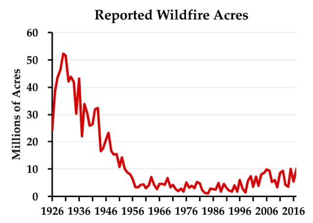
Some people use the data behind this chart to argue against anthropogenic climate change. The problem is that the data before about 1955 are a lie. Click image to go to the source data.

While some blame the increase in acres burned on human-caused climate change, skeptics of anthropogenic warming have pointed out that, according to the official records, far more acres burned in the 1930s — close to 40 million acres a year — than in any recent decade. The 1930s were indeed a decade of unusually bad droughts that can’t be blamed on anthropogenic climate change.

While the Antiplanner isn’t persuaded that recent fires are evidence of human-caused global warming, reports of acres burned from before about 1955 are not evidence of the opposite for a simple reason: the Forest Service lied. While the Antiplanner has alluded to this before, it’s important to tell the full story so that skeptics of climate change don’t reduce their credibility by using erroneous data.

The story begins in 1908, when Congress passed the Forest Fires Emergency Funds Act, authorizing the Forest Service to use whatever funds were available from any part of its budget to put out wildfires, with the promise that Congress would reimburse those funds. As far as I know, this is the only time any democratically elected government has given a blank check to any government agency; even in wartime, the Defense Department has to live within a budget set by Congress.

This law was tested just two years later with the Big Burn of 1910, which killed 87 people as it burned 3 million acres in the northern Rocky Mountains. Congress reimbursed the funds the Forest Service spent trying (with little success) to put out the fires, but — more important — a whole generation of Forest Service leaders learned from this fire that all forest fires were bad.

In 1924, Congress passed the Clarke-McNary Act, which allowed the Forest Service with (i.e., provide funds to) “appropriate officials of the various states or other suitable agencies” in developing “systems of forest fire prevention and suppression.” The Forest Service used its financial muscle to encourage states to form fire protection districts.

This led to a conflict over the science of fire that is well documented in a 1962 book titled Fire and Water: Scientific Heresy in the Forest Service. Owners of southern pine forests believed that they needed to burn the underbrush in their forests every few years or the brush would build up, creating the fuels for uncontrollable wildfires. But the mulish Forest Service insisted that all fires were bad, so it refused to fund fire protection districts in any state that allowed prescribed burning.

The Forest Service’s stubborn attitude may have come about because most national forests were in the West, where fuel build-up was slower and in many forests didn’t lead to serious wildfire problems. But it was also a public relations problem: after convincing Congress that fire was so threatening that it deserved a blank check, the Forest Service didn’t want to dilute the message by setting fires itself.

When a state refused to ban prescribed fire, the Forest Service responded by counting all fires in that state, prescribed or wild, as wildfires. Many southern landowners believed they needed to burn their forests every four or five years, so perhaps 20 percent of forests would be burned each year, compared with less than 1 percent of forests burned through actual wildfires. Thus, counting the prescribed fires greatly inflated the total number of acres burned.

The Forest Service reluctantly and with little publicity began to reverse its anti-prescribed-fire policy in the late 1930s. After the war, the agency publicly agreed to provide fire funding to states that allowed prescribed burning. As southern states joined the cooperative program one by one, the Forest Service stopped counting prescribed burns in those states as wildfires. This explains the steady decline in acres burned from about 1946 to 1956.

There were some big fires in the West in the 1930s that were not prescribed fires. I’m pretty sure that if someone made a chart like the one shown above for just the eleven contiguous western states, it would still show a lot more acres burned in real wildfires in the 1930s than any decade since — though not by as big a margin as when southern prescribed fires are counted. The above chart should not be used to show that fires were worse in the 1930s than today, however, because it is based on a lie derived from the Forest Service’s long refusal to accept the science behind prescribed burning.

This piece first appeared on The Antiplanner.

Randal O’Toole (rot@ti.org) is a senior fellow with the Cato Institute and author of the new book, Romance of the Rails: Why the Passenger Trains We Love Are Not the Transportation We Need, which will be released by the Cato Institute on October 10.

Source Link: http://www.newgeography.com/content/006096-the-sordid-history-forest-service-fire-data

ASEAN Environment Forest Fire Forestry HAZE Hotspots INDONESIA RFMRC-SEA SOUTHEAST ASIA Wildfire

BMKG Detects 12 Hotspots in Riau, Indication of Forest Fire

BMKG Detects 12 Hotspots in Riau, Indication of Forest Fire

Tuesday, 25 September 2018 | 13:06 WIB

TEMPO.CO, Pekanbaru – Meteorology, Climatology and Geophysics Agency (BMKG) detected 12 hotspots in Riau Province, which became an early indication of forest and land fire, on Tuesday morning.

Based on the data from BMKG Pekanbaru Station that was updated at 7:00 am, Riau still dominates the number of hotspots on Sumatra Island since the beginning of this week. In total, there are 23 hotspots in Sumatra, and 12 of them are in Riau.

There are five hotspots in South Sumatra, three in Lampung, two in Bangka Belitung, and one in Bengkulu.

Head of BMKG Pekanbaru Station, Sukisno stated the number of hotspots increased compared to on Monday afternoon, September 24, which was 11 hotspots. Of the 12 hotspots, the most were in Pelalawan District, five hotspots.

In Siak and Meranti Islands, there were three hotspots and Indragiri Hulu has one hotspot. In addition, there were two hotspots that have a level of confidence above 70 percent. “These two hotspots are in Pelalawan and Meranti Islands,” he said.

ANTARA

Source Link: http://en.tempo.co/read/news/2018/09/25/206921950/BMKG-Detects-12-Hotspots-in-Riau-Indication-of-Forest-Fire

ASEAN Environment Forestry Global International Regional RFMRC-SEA SOUTHEAST ASIA

New global study reveals the ‘staggering’ loss of forests caused by industrial agriculture

New global study reveals the ‘staggering’ loss of forests caused by industrial agriculture

By Erik Stokstad Sep. 13, 2018 , 3:30 PM

A new analysis of global forest loss—the first to examine not only where forests are disappearing, but also why—reveals just how much industrial agriculture is contributing to the loss. The answer: some 5 million hectares—the area of Costa Rica—every year. And despite years of pledges by companies to help reduce deforestation, the amount of forest cleared to plant oil palm and other booming crops remained steady between 2001 and 2015.

The finding is “a really big deal,” says tropical ecologist Daniel Nepstad, director of the Earth Innovation Institute, an environmental nonprofit in San Francisco, California, because it suggests that corporate commitments alone are not going to adequately protect forests from expanding agriculture.

Researchers already had a detailed global picture of forest loss and regrowth. In 2013, a team led by Matthew Hansen, a remote-sensing expert at the University of Maryland in College Park, published high-resolution maps of forest change between 2000 and 2012 from satellite imagery. But the maps, available online, didn’t reveal where deforestation—the permanent loss of forest—was taking place.

Source Link: http://www.sciencemag.org/news/2018/09/scientists-reveal-how-much-world-s-forests-being-destroyed-industrial-agriculture

Environment Forest Fire Forestry Hotspots INDONESIA RFMRC-SEA Wildfire

Bromo national park probes cause of 65-hectare wildfire

Bromo national park probes cause of 65-hectare wildfire

Aman Rochman | The Jakarta Post

Malang, East Java | Mon, September 3, 2018 | 01:59 pm

The management of Bromo Tengger Semeru National Park (TNBTS) in East Java is investigating the cause of a wildfire that burned at least 65 hectares of the park’s savannah and vegetation on Saturday.

The fire had been extinguished by Sunday afternoon, but local residents said on Monday morning that fire had again broke out in the area.

TNBTS head John Kennedy said the park was continuing with its investigation.

“The cause of the fire is still under investigation,” he said on Monday. “It is estimated that the fire burned 65 hectares [of Savannah],” he added.

The fire, which burned through the Pentongan Block of the Laut Pasir (Sand Sea) Tengger Resort, reportedly broke out around 9:45 a.m. local time on Saturday.

Initially, the park deployed 15 personnel to put out the fire. The team was later joined by officers of Malang regency’s Poncokusumo Police and 83 local residents.

But the fire continued to spread, said John, and that around 320 people from the area joined the firefighting effort.

John said that the park management temporarily closed on Saturday the Jemplang entrance on its Malang side. The entrance was reopened after the area was deemed safe for visitors.

“We reopened the [Jemplang] entrance on Sunday afternoon. Tourism activities are normal,” he said.

By Sunday evening, most of the fire had been extinguished except for several hot spots on Mount Watangan. (sau)

Source Link: http://www.thejakartapost.com/news/2018/09/03/bromo-national-park-probes-cause-of-65-hectare-wildfire.html

ASEAN Environment Forest Fire Forestry Global HAZE Hotspots RFMRC-SEA SOUTHEAST ASIA

Fires and haze return to Indonesia as peat protection bid falls short

Fires and haze return to Indonesia as peat protection bid falls short

by Aseanty Pahlevi, Hans Nicholas Jong, Zamzami on 29 August 2018

JAKARTA/PONTIANAK/PEKANBARU — Like their compatriots across Indonesia, a group of residents in the Bornean city of Pontianak celebrated the country’s Independence Day on Aug. 17 with a flag-raising ceremony.

But for them, the simple act of hoisting the Red-and-White was a physically taxing endeavor, thanks to the toxic haze billowing from a smoldering plot of peatland nearby. The sound of wood crackling in the fire could be heard as the participants, their surgical masks doing nothing to keep the smoke out of their eyes, stood through the ceremony. When it was over, they returned to what they were doing: working to put out the pockets of fire flaring up from the mulch-rich peat soil.

Beni Sulastiyo is one of the leaders of this group of residents of Pontianak, the capital of the province of West Kalimantan, who have banded together as volunteer firefighters. He says they see the fire problem as something that the whole community, and not just the government, needs to address.

“This should be a shared responsibility for everyone. As members of the community, we’re on the same page in helping the government,” he says.

Ateng Tanjaya is nearly 70, and has worked as a volunteer firefighter in Pontianak for more than 40 years. The work is often thankless, he says, and the hardships legion: lack of hoses and fire equipment, shortage of water, and scant funding and logistical support.

For these volunteers, the fires won’t end any time soon. The dry season is kicking in, and after a relatively haze-free 2016 and 2017, conditions this year look ripe for the fires to grow out of control.

Deadly heat

There have been nearly 2,200 fire hot spots recorded across Indonesia between Jan. 1 and Aug. 14, according to the Indonesian Forum for the Environment (Walhi), the country’s leading green NGO. West Kalimantan recorded the highest number of any province, at 779.

At least four people are confirmed to have died in the fires in the province. The latest victim, a 69-year-old farmer in Sintang district, reportedly died while trying to put out a blaze on his land on Aug. 19. Six days earlier, a family of three in Melawi district died in their burning house.

In Pontianak, the haze has sometimes been so thick that visibility is limited to 5 meters (16 feet). Flights into and out of the city’s Supadio International Airport are under constant threat of being cancelled or diverted whenever visibility drops below 1,000 meters (3,300 feet). Elsewhere across the province, schools were ordered shut on Aug. 20 when the haze worsened.

Satellite imagery from the Global Forest Watch platform shows smoke plumes in the most affected areas, including Pontianak and Ketapang district.

Air quality in Pontianak has been declining in recent weeks, according to data from the national weather agency, the BMKG, uploaded to the global monitoring platform IQAIR Air Visual. This has been marked by an increase in the concentration of tiny carcinogenic particles known as PM2.5 in the air.

These particles are small enough to enter the bloodstream; long-term exposure to them can cause acute respiratory infections and cardiovascular disease.

PM2.5 concentrations crossed into dangerous territory on Aug. 19 and 23, when the average daily levels registered at 73.5 and 79 micrograms per cubic meter, respectively — triple the World Health Organization’s guideline level of 25 micrograms per cubic meter in a 24-hour period.

‘Shoot on sight’

It’s a similar story across the Karimata Strait from Borneo, on the island of Sumatra. Norton Marbun, a resident of Rantau Benuang village in Riau province, says the fires there began on Aug. 14, razing the villagers’ oil palm farms.

He was out in the fields helping fight the flames, he says, and almost didn’t notice the fire closing in on his house, where his wife and children were sheltering. He rushed back to find the house, which he’d just finished building three months earlier after 11 years of saving up, filled with smoke. His wife didn’t want to leave — the house was all they had, she said — and Norton says he had to drag her and the kids out as the flames bore down.

They were barely out when a gas canister exploded inside the house. “If I’d been even 10 minutes late, maybe my family would have been skeletons inside the house,” Norton says.

They lost everything with their house, including two motorcycles. The family has since moved to a neighboring village. But even there they can’t escape from the haze.

“Now my children are having difficulty breathing due to the haze,” Norton says.

As growing forest and peat fires fan the haze across Riau, the military has been roped into the effort to fight the fires. A local military commander says nearly all the fires are set deliberately, and has issued a shoot-on-sight order for anyone caught doing so. (It’s not clear how this would be justified; Indonesian law has clear statutes proscribing extrajudicial shootings by law enforcement.)

Policy failure?

Forest and peat fires are an annual occurrence in Indonesia. In 2015, the country suffered one of its worst burning seasons in years, with more than 20,000 square kilometers (7,700 square miles) of land razed — an area four times the size of Grand Canyon National Park. The resultant haze sickened hundreds of thousands people in Indonesia and spread into Malaysia and Singapore.

On the heels of that disaster, President Joko “Jokowi” Widodo announced a series of measures aimed at preventing future fires. These include an ambitious plan to restore 24,000 square kilometers (9,300 square miles) of degraded peatland and imposing a moratorium on peat clearance.

The policies seem to have paid off, with a significant reduction in the number of hotspots in 2016 and 2017. Last year, officials recorded zero days with haze resulting from forest fires.

The government has repeatedly cited those figures as proof that its policies are working. But some of this year’s fires have flared up in regions prioritized by the government for peat restoration, including West Kalimantan and Riau.

Walhi, the environmental watchdog, says it has detected hotspots within peat hydrological units, the areas of peatland bordered by rivers or other bodies of water.

“The fact that this year the number of hotspots is very high in West Kalimantan shows that efforts to improve peat governance in the province have failed,” Anton P. Widjaya, director of Walhi’s West Kalimantan chapter, said at a recent press conference in Jakarta.

He said Walhi had compared the number of hotspots in peat areas before and after the government launched its program under the auspices of the Peatland Restoration Agency (BRG), and found no improvement.

“It turned out the number of hotspots didn’t differ that much,” Anton said. “So the work that the BRG has done on the ground hasn’t had a significant impact over the short term. The fact is that fires are still happening in these priority areas during the dry season.”

Riko Kurniawan, the director of Walhi’s Riau chapter, said the return of the fires in the province this year showed the government’s programs had been boosted in the previous two years by a less-severe dry season.

“Sure, there was no haze in Riau in 2016 and 2017, but that’s because the dry seasons those years were wetter, and because the government did its best to extinguish fires,” Riko said at the press conference. “But what about peat restoration and protection? As far as we’re concerned, that’s stagnant.”

Rewetting peat

BRG head Nazir Foead says the government’s peat restoration efforts might not be enough to prevent this year’s fires simply because of the sheer size of peat areas that have been degraded and are thus prone to burning again.

He cites the case of a village in Riau that was included in the peat restoration program last year. The village is surrounded by dozens of square kilometers of peatland that have to be rewetted to prevent fires from breaking out. To this end, the villagers blocked the canals that were previously dug to drain the land in preparation for planting.

But the work only took place two months before the onset of the dry season, and not all of the canals could be blocked in time.

“And indeed, fires happened this year on the edge of the village that hadn’t been restored yet,” Nazir says.

Even after drainage canals have been blocked, it can take years of rains before a peat area is restored to its original wet, sponge-like condition.

“If all the canals have been blocked, does that ensure there’ll be no more fire? Not really,” Nazir says. “Because the peatland has been dried out for so long, and so when the canals are blocked, the peatland isn’t immediately rewetted.”

In addition to working with villages that are prone to fires, the peat restoration program also requires companies to restore degraded peatland inside their concessions. The Ministry of Environment and Forestry has approved the peat restoration plans of 45 timber plantation companies and 107 oil palm and rubber plantation firms, according to Karliansyah, the ministry official in charge of environmental damage mitigation.

The ministry is still waiting for 80 more oil palm and rubber plantation companies and more than 30 timber plantation companies to submit and revise their restoration plans, he added.

“I guarantee that the 45 timber companies and the 107 plantation companies have done [peat restoration],” Karliansyah said. “But outside those companies, there might still be degraded peatland. If the weather is dry and there’s a small fire, then the fire could spread.”

Trading blame

The ministry’s fire mitigation chief, Raffles B. Pandjaitan, says this year’s increase in hotspots coincides with the start of the land-clearing season in West Kalimantan, where local farmers practice a traditional method of slash-and-burn called gawai serentak.

He says the farmers take advantage of the dry season, which peaks in August and September, to burn their land, after which they begin planting.

“It’s during this slash-and-burn season that the risk of fires is at its greatest,” Raffles said in a press release. “If we don’t keep the slash-and-burn practice under control, the fires will spread to other, bigger plantations.”

Walhi has refuted the government’s claim, saying many of the hotspots it has detected are in the concessions of large companies, not the farms of smallholders. The group says there have been 765 fire spots in corporate concessions so far this year.

Walhi executive director Nur Hidayati says it’s likely the government is blaming smallholders for this year’s fires because its own firefighting efforts so far have been focused on areas close to these villages.

“But [fires on] companies’ concessions that are far from villages are being ignored,” she told Mongabay in Jakarta recently.

Walhi spokeswoman Khalisah Khalid says that while some indigenous communities continue to practice slash-and-burn clearing, they do so in a way that keeps the fire contained. This keeps the fires from spreading outside the communities’ land and damaging the environment, according to a 2016 Walhi study on how traditional communities manage peatlands.

“Indigenous peoples have always been blamed for causing forest and peat fires,” Khalisah says. “But as this study shows, there are 20 steps that the Dayak indigenous tribe have to go through when they want to cultivate peatland.”

She also notes that a 2009 law that allows smallholders to clear land by burning up to 2 hectares (5 acres) — a stipulation aimed at preserving traditional methods of land clearing. By blaming traditional farmers for this year’s fires, the government has failed to understand the importance of local wisdoms about farming on peat, Khalisah says.

Walhi attributes the outbreak of fires this season on companies that went unpunished for previous fires and were thus emboldened to continue to the practice.

The government itself is also to blame for preventing the fires. That, at least, is the judgment of a court in Central Kalimantan province, which recently ruled in favor of a citizen lawsuit calling on the president and various ministers and other senior officials to be held accountable for the 2015 fires. In their suit, the plaintiffs argued that the government failed in its duty of protecting residents of Central Kalimantan from the impact of the fires.

The respondents in the lawsuit include the president; the ministers of environment, agriculture, land, and health; and the governor and provincial legislature of Central Kalimantan.

In its ruling, the high court in Palangka Raya, the provincial capital, ordered the respondents to pass regulation to mitigate land and forest fires

The government, however, is appealing the case to the Supreme Court, to the dismay of activists.

“I think there’s no need for the president to be defensive and file an appeal,” Walhi water and ecosystem campaigner Wahyu A. Pradana told local media. “What the president should do is obey all the orders in the ruling, because they’re for the sake of the people.”

Walhi has also called on the authorities to take action against companies with fires on their concessions, instead of going after local farmers. The environment ministry in mid-August sealed off concessions held by five companies in Kubu Raya district, West Kalimantan. It did not identify the companies by name.

“The government is very serious in handling land and forest fires,” Rasio Ridho Sani, the ministry’s head of law enforcement, said in a press release. “This move is to support our law enforcement effort so that there’s a deterrent effect. We will keep monitoring other burned locations using satellite and drone.”

Banner image: A group of locals in West Kalimantan participates in a flag-raising ceremony amid toxic haze from nearby peat fires. Image by Aseanty Pahlevi/Mongabay Indonesia. 

Article published by Hans Nicholas Jong
Source Link: https://news.mongabay.com/2018/08/fires-and-haze-return-to-indonesia-as-peat-protection-bid-falls-short/
ASEAN Environment Forest Fire Forestry International Regional RFMRC-SEA SOUTHEAST ASIA

Thinning forests resulting in fuelwood shortage

Thinning forests resulting in fuelwood shortage

By Dr. Michael A. Bengwayan

August 19, 2018

Fifty years ago, the Earth was annually losing forests the size of England. Today, the world loses 14 hectares of tropical forest every minute, mostly due to agriculture to support growing populations and fuelwood for cooking fires.

Yes, fuelwood is now a culprit in deforestation.

In Africa, Asia, South America—continents where large populations rely heavily on fuelwood for cooking—women, and children who bear the burden of looking for fuelwood, are walking longer hours just to search or cut trees for firewood.

Lack of fuelwood: The next energy crisis

Almost 2 billion rural people in developing countries do not have enough wood to cook their meals. Their number will grow to 2.5 billion by 2025.

Fuelwood supply and demand are coursed through head loads, camel trains, donkey and bullock carts, bicycles and shoulder loads. Ultimately, fuelwood ends up in cooking fires.

So says Earthscan, a London-based information think tank on environment issues citing United Nations Sustainable Report “Understanding Fuelwood” by Phil Barry Munslow and Phil Okeefe.

“The fuelwood problem has been isolated as an ‘energy crisis’ issue. Interventions to date have concentrated on narrowly defined technical options for supply enhancement or demand constraint. But there has been a failure to understand the fuelwood problem correctly,” it said.

“And unless developing nations adopt a serious and a no-nonsense approach to save its forests and woodlands, fuelwood will be the most serious energy crisis for the next 50 years,” it warned.

Rising fuelwood demand

The UN Food and Agriculture Organization (UNFAO) figures show that from 2000 to 2004, Southeast Asian countries have been using more wood for cooking with Cambodia, Lao PDR, Indonesia, Malaysia and the Philippines as the top users, followed by Myanmar, Thailand, and Vietnam.

Forest loss is acute in these countries, the second of the world’s great biodiversity hotspots. According to the 2005 report conducted by the UNFAO, Vietnam has the second-highest rate of deforestation of primary forests in the world. More than 90 percent of the old-growth rainforests of the Philippines have been cut.

Other Southeast Asian countries where major deforestation is ongoing are Cambodia, Indonesia, and Lao PDR.

Their combined fuelwood use is responsible for the deforestation of 72 percent of forests in the five-year span.

In South Asia top fuelwood users are Bangladesh, Bhutan, India, Maldives, Nepal, and Pakistan, accounting to 77 percent to 79 percent of total forest loss in the region, also in the five-year stretch. By region, South Asia, Southeast Asia, and China are the top fuelwood consumers.

Culprits

It would seem unfair to blame housewives—particularly those who toil the land—because generally, women farmers are known links to biological continuity.

To dispel such notion, the UNFAO made a study and noted that until 1980, firewood demand was a minor cause of deforestation. Women and children were collecting and using mostly branches and twigs while leaving trees standing.

But after that decade, due to rapid population growth in the rural areas, trees, big and young, started to be cut purely for fuelwood.

Often, young trees were the first to be cut, including those in reforested reservations and sanctuaries, UNFAO reported. When the small trees were consumed, fuelwood gatherers de-branch bigger trees causing many to die. Eventually, when the big trees dry and die, they are cut, UNFAO concluded.

The deplorable predicament worsens deforestation, and further aggravated by farmers clearing lands for livestock and crops.

To this day, forests are fair game as forest fragments crumble to almost daily cutting and gathering for fuelwood.

While not quite deforesting the globe, these problems are undermining the well-being of hundreds of millions of people in at least two continents—Asia and Africa.

Fuelwood consumption exerts pressure on the resource base if it is increasing at a rate higher than the growth of trees.

Inefficient stoves compounding the problem

Most rural folks in poorer Third World countries cook over open fires. The most common is the “three-stone fire,” the fire set between three stones bricks or whatever to support the cooking pot.

But this open fire system is wasteful and inefficient. As more wood is burned and wasted, more fuelwood is gathered, more trees cut, more forests ravaged.

To employ measures to improve fuel efficiency, there is a need to sustain a campaign for more efficient rural stoves.

Traditional stoves used inside rural homes have to be replaced by more energy-efficient stoves that don’t soot homes and cause upper respiratory ailments to family members.

Using alternative resources and solutions

THE UNFAO’s Fuelwood Program said 43 percent of the Philippine rural population depend on fuelwood for energy but is seldom using other forms of biomass like plant matter and animal wastes.

Until recently, most biomass consumers lived in rural areas. As populations have grown, and the number of trees has decreased, searching for fuelwood has indeed become a demanding task.

In the Cordillera Administrative Region, the Cordillera Ecological Center (CEC) has developed an alternative fuel for cooking from the oil of native tree Pittosporum resineferum.

CEC developed this as the region’s fuelwood supply for rural homes in all six provinces has become so scarce. It is becoming scarcer every day. Creeping deforestation has left many towns with less than 30-percent forest cover.

“The rate of deforestation is much faster than reforestation efforts. In many places, there is no deforestation to speak of,” said Dobbels Wallang CEC’s environmental specialist.

To many farmers, collecting firewood was a two-hour task 50 years ago. Today, it is almost an entire day expedition—every day.

“There are less and less dead trees and branches to cut,” Wallang added. “You are lucky if you can bring home a body-load after a day’s hunt,” he added.

Answering with woodlots

Because of the seriousness of the problem, the CEC is going around the rural areas training farmers on tree raising and tree planting by turning vacant spaces into woodlots.

The project calls for planting fast-growing nitrogen-fixing and multi-use tree species that yield branches fast and cut for firewood.

These include Pinus kesiya, Alnus japonica, Flemingia macrophylla and Calliandra calothyrsus.

More than a hundred woodlots have been established in at least six towns that continuously supply fuel needs of rural homes.

CEC raises yearly thousands of trees that are distributed to farmers groups, schools and civic organizations that help in reforestation efforts through community-based approaches.

In the Cordillera region, indigenous forestry practices are being popularized to answer the shortage of fuelwood, such as the muyung or pinugo, lakon or batangan, tayan, and lapat.

These are traditionally inherited woodlot properties and are privately owned that serve as primary sources of fuelwood, construction materials, food, and medicines.

They are storehouses of flora, containing from 100 to 264 tree and plant species, mainly indigenous, and endemic in the region, 90 percent of which are useful.

Link: https://businessmirror.com.ph/thinning-forests-resulting-in-fuelwood-shortage/

ASEAN Environment Forest Fire Forestry Global International Regional RFMRC-SEA SOUTHEAST ASIA

Water-bombing intensifies in Kuala Baram, raging forest fire worsens haze

Water-bombing intensifies in Kuala Baram, raging forest fire worsens haze

By Stephen Then

NATION | Sunday, 19 Aug 2018 | 12:14 PM MYT


MIRI: The Sarawak Fire and Rescue Department in Miri has intensified aerial water-bombing operations to contain a raging forest fire in Kuala Baram district.

The fire has also worsened the haze, recording an Air Pollutant Index (API) level at 113 on Sunday (Aug 19) morning. A reading of 0-50 is considered good, 51-100 moderate and 101-200 unhealthy.

Miri Fire chief Supt Law Poh Kiong said the Bomba air unit will be dropping more water to control the flames from spreading.

“Yesterday, we carried out 70 rounds of aerial water-bombings.

“This morning, we did more rounds,” he said.

Fire-fighters are also on the ground battling the flames on peat soils.

The wildfire in Kuala Baram is one of the dozens that are burning throughout the state.

Authorities are also worried about the haze and smog coming from West Kalimantan.

There are already more than 120 huge fires raging in the area.

Those fires measuring one sq km in size are called hotspots as they can be detected by satellites even 100km above earth.

Source Link: https://www.thestar.com.my/news/nation/2018/08/19/water-bombing-intensifies-in-kuala-baram-raging-forest-fire-worsens-haze/#5asqd2vHrkYcdtfF.99


Posts pagination

Previous 1 2 3 … 6 Next

RFMRC-SEA

Fire Simulator Training

https://rfmrc-sea.org/wp-content/uploads/2025/04/TRAINING-FIRE-SIMULATOR.mp4

Global Landscape Fire Awards 2019

https://rfmrc-sea.org/wp-content/uploads/2019/09/Global-Landscape-Fire-Award-2019.mp4

Meet Bambang Hero Saharjo, Indonesia’s go-to expert witness against haze-causing plantation firms (Mongabay)

https://rfmrc-sea.org/wp-content/uploads/2019/04/Meet-Bambang-Hero-Saharjo-Indonesias-go-to-expert-witness-against-haze-causing-plantation-firms.mp4

Multistrata Fieldwork (IPB and NASA) Riau, 18 Apr 2019

https://rfmrc-sea.org/wp-content/uploads/2019/06/WhatsApp-Video-2019-06-27-at-13.29.42.mp4

Calendar

January 2025
M T W T F S S
 12345
6789101112
13141516171819
20212223242526
2728293031  
« Jun    

Contact

IPB University Dramaga Campus Ulin Street, Forest Biology Build 2.1.4 Faculty of Forestry, Bogor 16680, West Java, Indonesia
Telp: (0251) 8421929
Wattsap : +62 812 9000 2231
Email: rfmrc@apps.ipb.ac.id

Login

Copyright © 2026 RFMRC-SEA
Theme by: Theme Horse
Proudly Powered by: WordPress