Singapore and the Smoke Haze Crisis

Vol. 53, Issue No. 3, 20 Jan, 2018


The 2013 and 2015 episodes of smoke haze over Singapore were some of the worst environmental crises in the nation’s history. Severe haze caused by land clearance fires in Indonesia blanketed Singapore for more than a month each time, leading to a dramatic shift in public attention and policies regarding the nation’s engagement with its neighbouring resource-extractive economies. This article reads the development of this crisis through the myth of the “air-conditioned nation,” arguing that it presents an opportunity to reconnect capitalism and regionalisation with their consequences.

(more…)

Forest fire risk assessment using hotspot analysis in GIS

This article by Dr. El-Said Mamdouh Mahmoud Zahran et al. is published in The Open Civil Engineering Journal, Volume 11, 2017
BENTHAM SCIENCE PUBLISHERS


The recent forest fire incidents are becoming a major concern as they seriously threaten the environment, economy and human’s safety. This research study aims to figure out forest fire hotspots using advanced hotspot analysis in Geographical Information Systems (GIS). Further, it can help propose appropriate preventive measures using Site Suitability and Network Analyses in GIS. The study focuses on Brunei Darussalam because it is increasingly struck by forest fire incidents among all regions in Southeast Asia.

(more…)

Indonesia’s Forest Fires: Limited Resources Hamper Fight

By | 28


Forest fires sweeping across Sumatra and Kalimantan in recent months prompted six Indonesian provinces to declare a state of emergency. Yet the scale of resources devoted to fighting and preventing forest fires remains far short of what is needed to turn around Indonesia’s rising rates of deforestation and meet Indonesia’s ambitious climate pledge.

(more…)

Firefighters coming home for Christmas

19 December 2017


Gardnerville resident Rhonda Vega said her Christmas will be complete when her son Darren and her son-in-law Aaron Leising are safe home from the Southern California fires.

Darren is a member of the Salmon Idaho Heli-Rappellers and Aaron went down with East Fork Brush 10.

(more…)

Is Indonesia’s fight against forest fires falling short?

Global Wildland Fire Early Warning

Global Early Warning System for Wildland Fire

Mapping Products

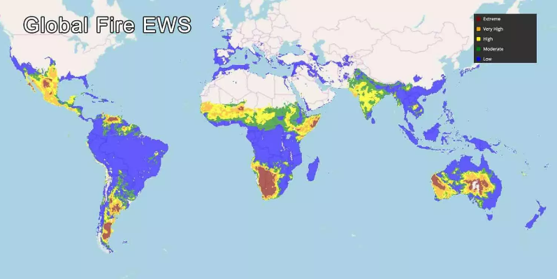
Global Fire EWS 10-day forecasts

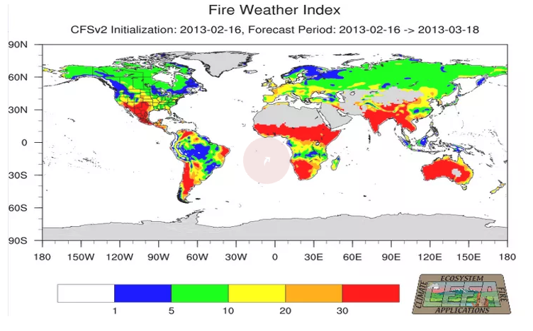
Global FWI Monthly Forecasts

Outline of Fire Danger Products in the Global Fire EWS

The fire danger indicators currently presented on the Global Fire Early Warning System (Global Fire EWS) are components of the Canadian Forest Fire Weather Index (FWI) System. The Global EWS provides 1-10 day forecasted FWI System data based on the Canadian Meterolological Centre’s (CMC) Global Deterministic Forecast System (GDPS). The FWI System components are currently calibrated to commonly used threshold values that identify low to extreme conditions. As such, the Global EWS provides a means of comparing relative fire danger conditions between countries, continents, and biomes; and the 1-10 day forecast identifies the expected future fire danger trend. This type of information is often useful for large-scale fire management decision-making such as planning cross-border suppression resource exchanges.

Although these indicators can be used to compare fire danger across the globe, the indicators are not calibrated to the local fire regime, which includes the influences of fuel, ignition sources, climate, fire management/suppression policy, etc. For that reason, the next stage in development of this system is regional calibration to adjust the fire danger scales using historical fire data (primarily remotely sensed) and weather data. This will calibrate the fire danger indicators to provide operational-level information such as potential for fire starts and difficulty of control. Regional calibration will be an on-going collaborative effort with regional and national agencies.

The FWI System has 6 components that represent fuel dryness and potential fire behaviour at the landscape level. All components are presented in the Global EWS:

  • Fire Weather Index (FWI) is a general indicator of fire danger and fire intensity
  • Buildup Index (BUI) indicates dryness of medium and large dead fuels
  • Initial Spread Index (ISI) is an indicator of rate of fire spread
  • Drought Code (DC) indicates dryness of deep, compact organic layers in the forest floor
  • Duff Moisture Code (DMC) indicates dryness of loosely compacted, upper organic layers of the forest floor; often used as a predictor of lightning-caused fires
  • Fine Fuel Moisture Code (FFMC) is an indicator of the dryness of dead fine fuels; often used as a predictor of human- and lightning-caused fires

More details on the FWI System can be found on the Canadian Wildland Fire Information System website , and the Canadian Meterolological Centre’s (CMC) Global Deterministic Forecast System (GDPS) at https://weather.gc.ca/grib/index_e.html . As the Global EWS develops in future, other fire danger indicators and weather forecast models will be included for multiple comparisons. As well, various remote sensing data will be incorporated to provide additional fire danger products.

International Workshop on National Guidelines on the Protection of Forests Against Fire

Bogor, Indonesia, 8-9 December 1997
(IFFN No. 18 – January 1998, p. 49-51)

Johann G. Goldammer, Editor IFFN

As a consequence of the fires and smoke pollution in Indonesia between 1982 and 1994 a cooperation agreement was made to develop a project “Integrated Forest fire Management in Indonesia Phase I: National Guidelines on the Protection of Forests against Fires”. The cooperation agreement between the International Tropical Timber Organization (ITTO), the Common Fund for Commodities (CFC), the Directorate General of Forest protection and Nature Conservation, Ministry of Forestry, and the Faculty of Forestry, Bogor University of Agricultural Sciences, was signed on 21 October 1996.

(more…)

Forest Fire Control Continues into The Rainy Season

01 October 2017


JAKARTA, NETRALNEWS.COM – Director of Forest and Land Fire Control, Ministry of Environment and Forestry (KLHK) Raffles B Panjaitan said the rainfall forecasts in several regions in Indonesia did not reduce the efforts to prevent and suppress forest and land fires (karhutla) by the KLHK Karhutla Control Brigade, Manggala Agni.

(more…)

Five named suspects in Jambi land, forest fires

9 September  2017


JAMBI, The Jambi Police have named five people as suspects during their investigation into seven land and forest fire cases, which occurred from January to August.

Jambi Police spokesperson Comr. Wirmanto Dinata said three out of the seven cases were handled by the Tebo Police while two cases were investigated by the Batanghari Police. The East Tanjungjabung Police and the Muarojambi Police handled one case each.

(more…)

Jambi land, forest fires continue

6 September 2017


JAMBI, While the number of hot spots in some areas across Sumatra is declining with the onset of the rainy season, land and forest fires in Jambi continue to break out.

The Jambi administration’s Land and Forest Fire Task Force data shows that fires in the province cover 488 hectares in seven regencies. They comprise Batanghari, Bungo, East Tanjungjabung, Muarojambi, Sarolangun, Tebo and West Tanjungjabung.

(more…)