By: Robi Deslia Waldi
Bangkok, March 26, 2026 — Thailand continues to grapple with a severe wildfire and haze crisis, as new satellite imagery reveals widespread fire activity across mainland Southeast Asia, intensifying concerns over air quality and environmental damage.
Data from the Geo-Informatics and Space Technology Development Agency (GISTDA) recorded 1,488 hotspots nationwide on March 23, with more than 80 percent concentrated in forested areas. The findings highlight that forest fires remain the primary driver behind the country’s worsening haze and rising levels of harmful PM2.5 pollution.
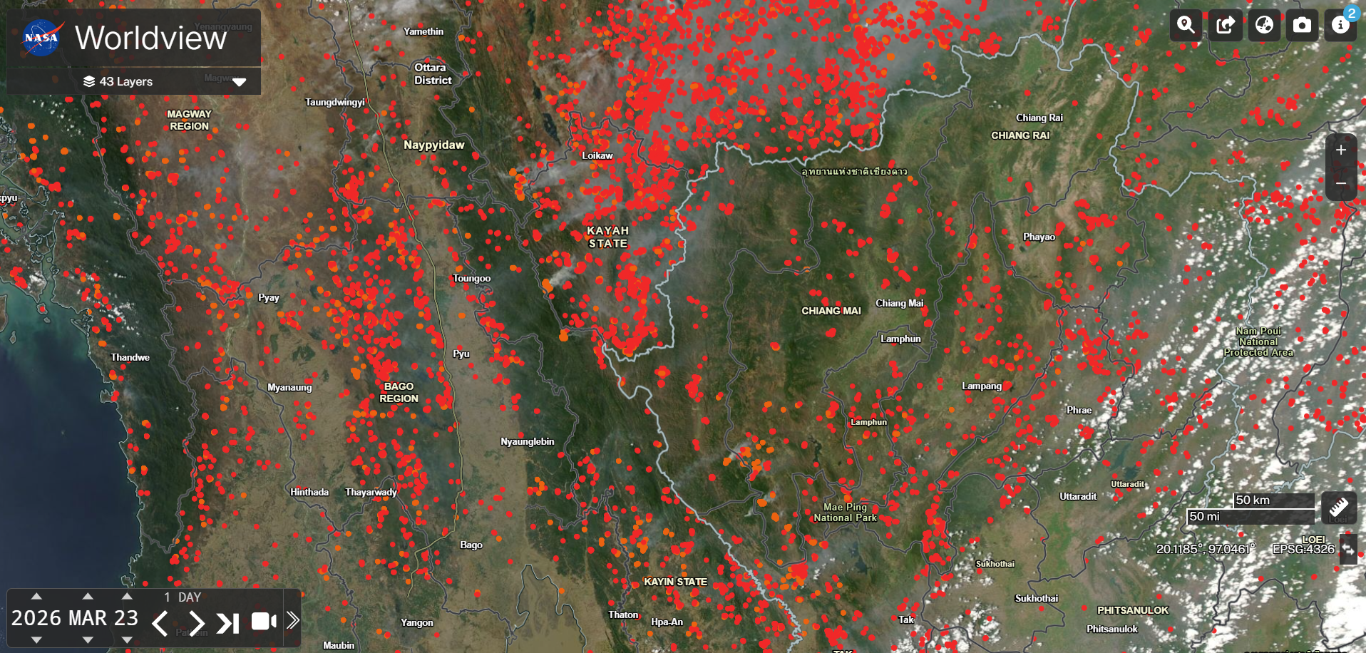
However, the situation extends beyond Thailand’s borders. Satellite imagery from NASA Worldview on the same date shows a far more alarming regional picture, with dense clusters of hotspots across neighboring countries.
The most intense concentration was observed in Myanmar, particularly in regions such as Kayah State, Kayin State, and Bago Region. Thousands of fire points were detected, indicating large-scale burning activity likely driven by a combination of forest fires and land clearing practices.
In northern Thailand, hotspots were widely distributed across provinces including Chiang Mai, Lampang, and Chiang Rai. Although less dense than in Myanmar, the widespread distribution suggests numerous small to medium-scale fires contributing cumulatively to the haze problem.
The scale of fire activity across the region raises serious concerns over transboundary haze, as smoke from neighboring countries drifts into Thailand, further deteriorating air quality. Myanmar recorded the highest number of hotspots in the region, followed by Laos, placing Thailand among the most affected countries.
Experts warn that the concentration of fires in forested and mountainous areas makes suppression efforts more difficult and increases the risk of prolonged environmental impact. The combination of dry weather, high temperatures, and human activities such as agricultural burning continues to fuel the crisis.
In response, GISTDA has urged the public to monitor real-time hotspot updates and wildfire risk forecasts through its disaster monitoring platform. Authorities also emphasize the importance of regional cooperation, as the haze crisis can no longer be addressed by individual countries alone.
The current situation serves as a stark reminder that wildfire and haze pollution in Southeast Asia is a shared challenge. Without coordinated action and stronger preventive measures, the impacts on public health, ecosystems, and regional stability are likely to worsen in the coming weeks.