‘Transboundary Haze’: The Seasonal Pollution Plaguing Southeast Asia

‘Transboundary Haze’: The Seasonal Pollution Plaguing Southeast Asia

2018/11/08, Environment | By Helena Varkkey

Transboundary haze is a form of seasonal air pollution affecting up to six Southeast Asian countries on an almost annual basis.

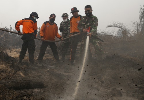
The first reports of this phenomenon emerged in the 1980s, and the most recent serious episode took place in 2016. The most affected countries are Indonesia, Singapore, and Malaysia. The particulate and aerosol matter that makes up the haze originates from forest and peat fires occurring during the dry season, mostly in Indonesia. When this permeates the troposphere and travels across national borders, it is known as transboundary haze.

RTX2N6PN
People take photos near the Singapore Flyer observatory wheel shrouded by haze, Aug 26, 2016.

The countries and people within reach of this smoky shroud suffer serious health, economic, and environmental consequences during each episode. The fine particles in the haze permeate deep into the lungs, which can cause serious respiratory problems, especially among young children and the elderly, sometimes resulting in death. Ophthalmological, dermatological, and psychological issues are also commonplace.

Sick days taken and school closures (during which parents often stay home to care for their children) cause significant losses in workforce productivity. These countries’ tourism industries suffer as well, as visitors have no interest in hazy skylines. Agricultural productivity and the general state of the environment also decline as the haze blocks out the sun and slows down photosynthesis.

Whither the weather solution?

With the countries affected all situated within the Southeast Asian region, the Association of Southeast Asian Nations (ASEAN) was quickly looked upon to be the driver of a workable regional solution to the haze. ASEAN began to formally identify transboundary haze as part of its remit in 1985. However, despite various ASEAN agreements, initiatives, and task forces since then, the haze persists. The haze’s effect on member countries is dire, and its causes are seemingly well understood, so ASEAN’s continued inability to effectively mitigate it is puzzling.

Scholars have laid the blame for ASEAN’s “failure” to solve the haze on weak regional governance; specifically, the limitations of its model of regional engagement through consensus, non-interference, non-confrontation, sensitivity, and politeness, as well as non-legalistic procedures – the so-called “ASEAN Way.” Describing this model as a “doctrine” to be adhered to at all costs, scholars such as Vinod Aggarwal and Jonathan Chow argue that member states’ desire to eliminate the haze has been unable to compete against the stronger desire to comply with the ASEAN Way.

However, other ASEAN observers, such as Tobias Nischalke and Shaun Narine, have argued that member states do not blindly follow the ASEAN Way. Nischalke’s research uncovered many examples where the ASEAN Way was only moderately adhered to at best. This contention was the entry point of my research: has ASEAN been failing on the haze because states are duty-bound to adhere to norms that do not encourage effective regional environmental governance? Or have the states been choosingto adhere to these norms because it is in their interests to do so? If so, what are these interests, who has been shaping them, and why are they not in line with a haze-free ASEAN?

It’s the peat, stupid!

To answer these questions, I spent six months in Indonesia, Singapore, and Malaysia conducting semi-structured interviews with over 100 individuals with experience in haze governance, including government and ASEAN officials, journalists, plantation company representatives, non-governmental organization workers, and academics.

RTS1C9G
Fires on palm oil plantations, such as this one in Jebus village on the Indonesian island of Sumatra, are responsible for a great deal of transboundary haze.

During these conversations, several points became clear.

Firstly, the type of fire matters. While regular forest fires are most common, they usually burn tree canopies. This produces little smoke and often results only in short-term, localized haze. Peat fires, on the other hand, can spread below the surface, reaching soil. Carbon-rich soil produces especially thick and sooty smoke when burnt, and this smoke can travel great distances. These fires are also harder to put out. Hence, a small amount of fires (on peatlands) are responsible for a large portion of transboundary haze.

Secondly, peat is not naturally fire-prone. In their natural state, peatlands are flooded year-round – fires only occur when peatlands are drained in preparation for planting. This dries out the peat and makes it flammable.

Thirdly, due to the importance of peatlands as carbon sinks, Indonesian law generally does not allow these areas to be developed. Despite this, and due to the decreasing availability of mineral soil, an increasing amount of peatlands have been opened for agriculture, especially for palm oil. A trend emerged, where the increasing severity of the haze matched the region’s palm oil boom in recent decades.

Hazy networks

Further interviews revealed that large plantation companies, both local and from Malaysia or Singapore, have managed to obtain licenses to access peatlands to plant crops like oil palm. Some of these companies deliberately use fire as the cheapest and quickest way to clear the land for planting. Even if these companies do not deliberately burn, the act of draining these lands makes them prone to accidental fires.

I found that strong patronage networks in this sector have enabled this to happen. Patronage is defined as a situation where an individual of higher socioeconomic position (patron) uses his influence and resources to provide protection or benefits for a person of lower status (client), who reciprocates by offering support and assistance to the patron. In this case, government patrons have provided the benefit of licenses to their clients, the business elites who own or are affiliated with these plantation companies. Furthermore, clients have also enjoyed their patrons’ protection from prosecution for haze-producing fires.

RTS37UI
A woman looks towards the Prime Minister’s office, which is shrouded in haze, in Putrajaya, Malaysia on Oct 6, 2015.

These networks are at work even at the ASEAN level. When they represent Indonesia at ASEAN, the patrons are still compelled to protect their clients. An effective ASEAN haze mitigation strategy would mean that their clients would lose access to lucrative income, and risk being prosecuted. Hence, these patrons choose to use the ASEAN Way, especially the principles of non-interference and non-legalistic procedures, to block any meaningful strategies. Malaysian and Singaporean patrons follow suit, as they also act to protect their own complicit companies. I argue that these patronage networks better explain the decisions made at the ASEAN level that have led to the failure of the bloc to solve the haze problem.

Blue skies ahead?

Since my field research, there have been some positive developments. The government of Singapore has shown a shift in its national interests, away from protecting its clients and toward the well being of its people. After several public displays of frustration with ASEAN’s lackadaisical efforts, Singapore ultimately passed its landmark Transboundary Haze Pollution Act in 2014, which empowered its courts to prosecute any party (even non-Singaporean) found to have caused haze in Singapore.

Singapore, however, has not yet been able to use this act in court, largely due to the non-cooperation of Indonesia. While ASEAN member states still meet regularly to strategize on haze matters, the strategic use of the ASEAN Way continues to limit any meaningful progress. However, as Singapore has shown, change is not impossible. I remain hopeful that other member states will eventually follow in Singapore’s footsteps to act in the common interest of the people of the region.

Helena Varkkey is a senior lecturer in the Department of International and Strategic Studies at the University of Malaya. She received her PhD in international relations from the University of Sydney in 2012 and her first book, “The Haze Problem in Southeast Asia: Palm Oil and Patronage,” was published by Routledge based on the above research in 2016.

Read Next: INDONESIA: Palm Oil Linked to Deforestation Remains on Store Shelves

This article was originally published in AsiaGlobal Online, a Hong Kong-based source of Asian perspectives on global issues. The News Lens has been authorized to republish this article.

TNL Editor: Nick Aspinwall (@Nick1Aspinwall)

Source Link: https://international.thenewslens.com/article/107781

Forest fire breaks out on slopes of Bali’s Mount Agung

The forest fire breaks out on slopes of Bali’s Mount Agung

Coconuts Bali | 

a view of a river: mount agung forest fire bali post sept 28 2018

Mount Agung forest fire Bali post sept 28, 2018

The Suwung landfill in South Denpasar is not the only place burning in Bali at the moment.

A forest fire broke out on the slopes of Bali’s Mount Agung on Thursday.

Wooded areas around Daya and Kubu have been observed smoking, however, this fire’s not an easy one to put out.

The burn area lies inside steep terrain of the eruption hazard zone of Mount Agung, which persists at level III “standby” status for an eruption.

There continues to be an exclusion zone recommended by Indonesia’s volcanology center, encompassing a four-kilometer radius from the volcano crater, which has been extended and reduced back down to four kilometers a number of times since the Bali volcano rumbled back to life last year. Outside of this exclusion zone, Bali remains safe and tourists are urged by the government to still come for holiday.

Head of the Karangasem Fire Department I Nyoman Sutirtayasa said that his department has been coordinating with officers from East Bali Forest Protection Management (RPH) to put out the fire at an altitude of about 1,500 meters above sea level.

“Officers from East Bali RPH are conducting fire monitoring at monitoring posts,” Sutirtayasa told Bali Post on Thursday.

The officers are ready to start fighting the fire if it spreads further down outside of the exclusion zone, but at the moment the terrain is to challenging to access the burn location, according to the fire department head.

“The route to the (fire) location is difficult. The effort that can be done now is to prevent the spread of the fire to the lower slopes. If we go up, we do not dare enter the danger zone,” Sutirtayasa told Tribun Bali.

“The area of land burning is getting wider. The fire has reached the south of Mount Agung and has spread to forested land above Pajenengan Temple, Pempatan Village. The cause of the fire is still unknown,” Sutirtayasa said.

Meanwhile, Made Warta, head of the East Bali Forest Management Unit says that his officers have been working with local residents to try and contain the downward spread of the fire. They also dare not risk entering the danger zone, but they have been extinguishing flames trying to come down the mountain.

There are three apparent hotspots that have appeared and the burn area is estimated to be about a hectare, Warta told Tribun.

There isn’t even a hiking trail to one of the areas, Warta explained of the difficult access.

Hot weather and strong winds have been contributing factors in allowing the fire to spread and flare up.

The post Forest fire breaks out on slopes of Bali’s Mount Agung appeared first on Coconuts.

Source Link: https://www.msn.com/en-sg/news/world/forest-fire-breaks-out-on-slopes-of-bali-e2-80-99s-mount-agung/ar-BBNEAcX

BMKG Detects 12 Hotspots in Riau, Indication of Forest Fire

BMKG Detects 12 Hotspots in Riau, Indication of Forest Fire

Tuesday, 25 September 2018 | 13:06 WIB

TEMPO.CO, Pekanbaru – Meteorology, Climatology and Geophysics Agency (BMKG) detected 12 hotspots in Riau Province, which became an early indication of forest and land fire, on Tuesday morning.

Based on the data from BMKG Pekanbaru Station that was updated at 7:00 am, Riau still dominates the number of hotspots on Sumatra Island since the beginning of this week. In total, there are 23 hotspots in Sumatra, and 12 of them are in Riau.

There are five hotspots in South Sumatra, three in Lampung, two in Bangka Belitung, and one in Bengkulu.

Head of BMKG Pekanbaru Station, Sukisno stated the number of hotspots increased compared to on Monday afternoon, September 24, which was 11 hotspots. Of the 12 hotspots, the most were in Pelalawan District, five hotspots.

In Siak and Meranti Islands, there were three hotspots and Indragiri Hulu has one hotspot. In addition, there were two hotspots that have a level of confidence above 70 percent. “These two hotspots are in Pelalawan and Meranti Islands,” he said.

ANTARA

Source Link: http://en.tempo.co/read/news/2018/09/25/206921950/BMKG-Detects-12-Hotspots-in-Riau-Indication-of-Forest-Fire

Wildfires raze hectares of land in Sukabumi nature reserves

Wildfires raze hectares of land in Sukabumi nature reserves

News Desk | The Jakarta Post

Jakarta | Tue, September 4, 2018 | 12:44 pm

Wildfires engulfed hectares of land in the Cikepuh and Cibanteng nature reserves in Sukabumi, West Java, between July and August.

The West Java Natural Resources Conservation Agency (BKSDA) recorded that at least 27 hotspots, which were located on the savannah, had scorched about 232 ha of the two nature reserves’ total area, kompas.com reported.

Kusmara of the BKSDA said the savannah was prone to fires during the dry season.

The fires, he added, were also found inside the buffer zones close to land owned by local residents.

“We are still investigating the cause of the fire because there is suspicion of illegal activities in the area,” Kusmara said on Monday, as quoted by kompas.com, without giving more information.

Cikepuh and Cibanteng are part of the Ciletuh-Pelabuhan Ratu National Geopark, which gained global recognition as a UNESCO Global Geopark earlier this year.

In September last year, fires razed at least 19 ha of forest in Cikepuh.

Kusmara said the authorities were continuing to work to prevent further fires, including encouraging local residents to take part in wildfire prevention campaigns.

During this year’s dry season peak between July and August, the country saw an increase in the number of land and forest fires in several provinces, with West Kalimantan becoming the region with the most hotspots to date. (kuk/ipa)

Source Link: http://www.thejakartapost.com/news/2018/09/04/wildfires-raze-hectares-of-land-in-sukabumi-nature-reserves.html

Bromo national park probes cause of 65-hectare wildfire

Bromo national park probes cause of 65-hectare wildfire

Aman Rochman | The Jakarta Post

Malang, East Java | Mon, September 3, 2018 | 01:59 pm

The management of Bromo Tengger Semeru National Park (TNBTS) in East Java is investigating the cause of a wildfire that burned at least 65 hectares of the park’s savannah and vegetation on Saturday.

The fire had been extinguished by Sunday afternoon, but local residents said on Monday morning that fire had again broke out in the area.

TNBTS head John Kennedy said the park was continuing with its investigation.

“The cause of the fire is still under investigation,” he said on Monday. “It is estimated that the fire burned 65 hectares [of Savannah],” he added.

The fire, which burned through the Pentongan Block of the Laut Pasir (Sand Sea) Tengger Resort, reportedly broke out around 9:45 a.m. local time on Saturday.

Initially, the park deployed 15 personnel to put out the fire. The team was later joined by officers of Malang regency’s Poncokusumo Police and 83 local residents.

But the fire continued to spread, said John, and that around 320 people from the area joined the firefighting effort.

John said that the park management temporarily closed on Saturday the Jemplang entrance on its Malang side. The entrance was reopened after the area was deemed safe for visitors.

“We reopened the [Jemplang] entrance on Sunday afternoon. Tourism activities are normal,” he said.

By Sunday evening, most of the fire had been extinguished except for several hot spots on Mount Watangan. (sau)

Source Link: http://www.thejakartapost.com/news/2018/09/03/bromo-national-park-probes-cause-of-65-hectare-wildfire.html

Shoot-on-sight order issued as Riau fights fires

Shoot-on-sight order issued as Riau fights fires

PUBLISHED AUG 18, 2018, 5:00 AM SGT

Fewer hot spots now, but locals still favor the slash-and-burn method of clearing land

The number of hot spots in the Indonesian province of Riau went down to 27 yesterday from 121 a day earlier with the authorities stepping up measures to fight forest and peatland fires, including a shoot-on-sight order issued by the military against firestarters.

Mr. Jim Gafur, head of emergency response at the Riau disaster management agency (BPBD), told The Straits Times yesterday that fire-fighting teams had succeeded in dousing and containing the fires.

He said the worst-affected areas were north of Pekanbaru, the provincial capital, Bengkalis, Dumai, and Rokan Hilir.

“The scale of the fires has declined significantly today compared with the previous two days. We are doing massive operations,” Mr Jim told The Straits Times by telephone. “Fires had spread because the wind speed surged… We quickly responded to this change of weather.”

Winds, which have become stronger in Sumatra as a result of tropical storm Bebinca in the South China Sea, have moved north-east.

At this time of the year, they usually blow north until November or December before turning south-west, Mr. Jim said.

“Prevailing winds over the northern part of the ASEAN region are forecast to continue blowing from the south-west or west (towards north-east and east), and may strengthen briefly over the next few days under the influence of the (Bebinca) storm,” the Meteorological Service Singapore posted on its website yesterday afternoon.

It added that it was continuing to observe smoke haze from hot spots in Riau and Kalimantan.

Mr. Jim ruled out any possibility of haze moving south towards Palembang, which is co-hosting the 18th Asian Games. No hot spots have been detected in Palembang or South Sumatra so far.

“We are intensifying water bombings. We have been deploying five helicopters, two of which are bigger ones that are able to carry 5,000 liters on each trip. Ground firefighting efforts have also been intensified,” Mr. Jim said.

Commander of the Riau Land and Forest Fire Task Force Sonny Aprianto issued a shoot-on-sight order across Riau on Thursday against those caught red-handed clearing land by burning, state news agency Antara reported.

“Ninety-nine percent of the land and forest fires in Riau province are related to the intentional acts of irresponsible people,” Antara news agency quoted Brigadier-General Sonny as saying.

He also said that the authorities have not had much success in convincing people not to clear land by burning, acknowledging instead that the slash-and-burn method has become more widespread.

Several arsonists have been nabbed, he said, with at least three cases in Dumai city now ready for trial.

Satellites identified 121 hot spots in the province on Thursday morning – a big jump from the 22 detected on Wednesday afternoon, said the Meteorology, Climatology and Geophysics Agency (BMKG).

The military on Thursday also began deploying troops to fire-prone areas in the province, reported Riauterkini.com news portal.

President Joko Widodo and other senior leaders have ordered intensified efforts to combat the land fires to ensure that the Asian Games, which opens today, will not be disrupted.

The city of Palembang, in South Sumatra province, is co-hosting the quadrennial games with the capital Jakarta till Sept 2.

Link: https://www.straitstimes.com/asia/se-asia/shoot-on-sight-order-issued-as-riau-fights-fires

Forest Fire Begins to Occur in Areas of Indonesia

Editor (ENG) Indra Sutrisno

Editor (INA)Sulha Handayani

SAMPIT, NNC – Land fires began to occur in Sampit, East Kotawaringin District, Central Kalimantan, which allegedly was cauesd by a reduce in rain intensity.

“Land fire occurred at Jenderal Sudirman St. KM 10 with two hotspots,” East Kotawaringin Fire and Rescue Department Chief Rihel said in Sampit.

The fire occured on empty land on the side of the highway. Personnels received information from the public at around 4 p.m and immediately rushed to the location.

The East Kotawaringin Fire and Rescue Department deployed one firetruck. Personnels from the East Kotawaringin Police Resort also rushed to the scene by deploying motorcycles equipped with an extinguisher. East Kotawaringin Resort Police Operational Division Chief Adj. Commissioner Boni Ariefianto came to the scene along with several armed forces and East Kotawaringin Regional Disaster Management Agency personnels.

“We urge the people to take part in preventing land fires. The lack of rainfall has increased the chances of forest and land fire,” Rihel said.

Head of East Kotawaringin Regional Disaster Management Agency Muhammad Yusuf said according to the information from the Meteorology, Climatology and Geophysics Agency, the peak of dry season is expected to happen in August.

The people of East Kotawaringin must stay alert as the district is included as an area prone to forest and land fires.

“Drought is predicted to start on the third week of this July, possibly somewhere around July 20. Inorder to anticipate it, a forest and land fire emergency alert status is planned to be set mid-July,” Yusuf said Thursday, July 12.

Source Link: http://www.en.netralnews.com/news/currentnews/read/22470/forest.fire.begins.to.occur.in.areas.of.indonesia

Swamps and Wildfires: A Dangerous Combination

Swamps and Wildfires: A Dangerous Combination


“Know your enemy” is a perfect motto for wildland firefighters. The brave souls who’ve chosen this line of work understand its many dangers. Forest fires are not their only source of trouble: One of the biggest challenges these men and women can face is an out-of-control peatland swamp fire. Don’t let the standing water fool you: Bogs and swamps are fertile terrains for a tenacious, sneaky kind of inferno that smolders underground and might spend years lurking beneath the surface.

For Peat’s Sake

Recognized as one of the American South’s greatest natural wonders, the vast Okefenokee Swamp rests on the Georgia-Florida border. In 2007, lightning and a felled power line sparked a plague of converging wildfires in and around this storied wetland. More than 926 square miles (2,398 square kilometers) worth of vegetation were torched in the Okefenokee’s two home states. Huge columns of town-smothering smoke could be seen from Atlanta to Orlando. By the time the crisis ended, it had cost the citizenry an estimated $130 million in damages and firefighting expenses.

The Okefenokee is accustomed to this sort of thing. Prior to ’07, the swamp had endured massive fires in 1844, 1860, 1910, 1932, 1954 and 1955. History repeated itself once again in 2011 when another round of brushfires terrorized the swamp for more than eleven months straight.

There’s a reason why this boggy area — a lush place that’s teeming with fish, alligators and aquatic plants — gets so many fires. And that reason is peat.

Peat is a carbon-rich, organic turf that covers 3 percent of the world’s land surface. About 50 to 70 percent of all wetlands, including the Okefenokee Swamp, is situated above large deposits of this material. Its main ingredient is dead plant matter that hasn’t fully decomposed. Remains of other deceased organisms are also contained within blocks of peat, along with minerals absorbed in the local sediment.

To get peat, you generally need an area where there’s little water beneath the ground and microorganisms in the soil are creating an anaerobic — or low-oxygen — environment. As more and more organisms die off, peat steadily accumulates over hundreds or thousands of years. Forests and wetlands can form over these peat sheets, the thickest of which are more than 50 feet (15.2 meters) deep. It’s thought that the oldest peats on the planet started forming 12,000 years ago — right after the last ice age.

Smoldering Real Estate

Pressure from above slowly drives peat deeper into the Earth, where it eventually becomes coal. And like that prized mining commodity, peat harbors a lot of trapped carbon from dead life forms. In fact, peat plays host to a third of all the carbon that’s stored inside the world’s soils. All this carbon renders the substance highly flammable. Even damp peat makes for good kindling when water makes up less than 55 percent of its total weight.

A spark at the surface might be all that’s required to ignite the peat under a swamp or forest. Whereas living trees burst into licks of orange flame, peat catches fire in a less dramatic way: It smolders like a lit cigarette. Once they get started, peat fires move at a gradual pace, creeping along through the substrate. The slow burns have been known to last for years before getting extinguished. They can also reach the surface, setting some trees or bushes ablaze. It’s not unheard-of for a peat fire to do exactly that and then retreat back underground, only to reappear later on. In 2014, seven Canadian peat fires caused surface-level damage and then went under before they resurfaced the following year.

Fires liberate the trapped carbon, sending it into the atmosphere in the form of carbon dioxide. This has the unfortunate effect of triggering longer dry seasons in places where peat bogs naturally occur, making them more likely to ignite. It’s a nasty feedback loop — and a big contributor to our climate change problems.

What’s more, smoke from these fires aggravates respiratory problems for those who inhale it. A 2015 outbreak of the bog burnings in southeast Asia led to dense, low-lying clouds of haze. We don’t know how many deaths this caused, but one team of researchers came up with a tentative figure of 100,300 fatalities distributed between Indonesia, Malaysia, and Singapore.

Fighting back isn’t easy. Sometimes, you can smother a peatland fire by pumping water into the turf, but this technique requires a huge amount of time, effort, and planning. Waiting for them to die of natural causes is an exercise in frustration. As we’ve established, it can take months or years for one of these fires to burn through its fuel supply. Intense rainstorms have been known to put them out, but if the peat gets struck by lightning, that can make it smolder again.

Alas, a wildland firefighter’s job is never done.

Source Link: https://science.howstuffworks.com/nature/natural-disasters/swamps-and-wildfires-dangerous-combination.htm

Rain puts out forest fire on Mt Lawu

Rain puts out the forest fire on Mt Lawu

Ganug Nugroho Adi

The Jakarta Post

Karanganyar, Central Java | Thu, June 21, 2018, 04:27 pm

Heavy rain, which fell on Wednesday, has doused the forest fire on Mount Lawu, Karanganyar regency, Central Java.

Climbers, who were on the peak at the time of the fire, have been safely evacuated. However, all trails have been closed until further notice.

“Yes, the fire is out,” said Bambang Djatmiko, the head of the Karanganyar Disaster Mitigation Agency (BPBD), on Thursday. “The rain that fell on Wednesday afternoon doused it.”

Bambang confirmed that there were about 400 climbers on the mountain when the fire broke out. The BPBD assigned dozens of volunteers from Candi Cetho to fight it and look for climbers.

Around 200 people were evacuated by volunteers from BPBD Karanganyar and Search and Rescue (SAR), while the rest had descended the mountain on their own.

“The last of the 50 climbers have descended,” said Bambang. “They were not trapped but took a rest at the second post, which is far from the hot spot. All of them have returned uninjured.”

Meanwhile, the head of state-run forestry firm Perhutani’s forest functionary office (BPKH) in North Lawu, Edy Saryono, said the hot spot was first detected on Tuesday afternoon on the Argo Tiling peak.

 “Not a single tree was destroyed by the fire. So there’s no need to plant new ones,” added Edy.

He said although the source of the fire was still unknown, he assumed it could have been caused by locals who were making charcoal in the area. (wir/wng)

Source Link: http://www.thejakartapost.com/travel/2018/06/21/rain-puts-out-forest-fire-on-mt-lawu.html

Minister reviews forest fires during Eid holidays

Minister reviews forest fires during Eid holidays

Reporter: Sri Muryono 

Jakarta (ANTARA News) – The Minister of Environment and Forestry Siti Nurbaya Bakar took to the field to monitor the handling of forest and land fires in the country during Eid Fitr or Lebaran holidays.

“In addition to monitoring the reports of forest and land fires (karhutla) every day, I monitored the handling of karhutla yesterday on the plane to some areas,” said Siti Nurbaya in a written statement received in Jakarta on Sunday.

The air monitoring conducted on the weekend or the second day of Eid Fitr covers some of the fire-prone points of forest and land in Sumatra.

Siti Nurbaya expressed her gratitude for the dedication of Manggala Agni (forest fire control team) members of the Environment and Forestry (KLHK). The team is composed of members of the Indonesian Defense Forces (TNI), National Police (Polri), BPBD (Local disaster mitigation agency), Care for Fires Community (MPA) and related parties who tirelessly tackled karhutla during the dry season as it is today.
Although it is still in the atmosphere of Lebaran holidays, yet the field team is still working hard to keep Indonesia smoke-free. “I am very grateful to them,” she said.

In recent days, said Siti Nurbaya, Manggala Agni, Daops (operation area) Aceh intensively has conducted karhutla handling in South Aceh assisted by Manggala Agni of Sibolangit Daops.

“Thank God, fires at several points have been put out. Karhutla in Ketapang, West Kalimantan, was also successfully overcome, but once I still ask the Manggala Agni to remain vigilant,” he said.

Editor: Andi Abdussalam